
By Cathy Jones 2023
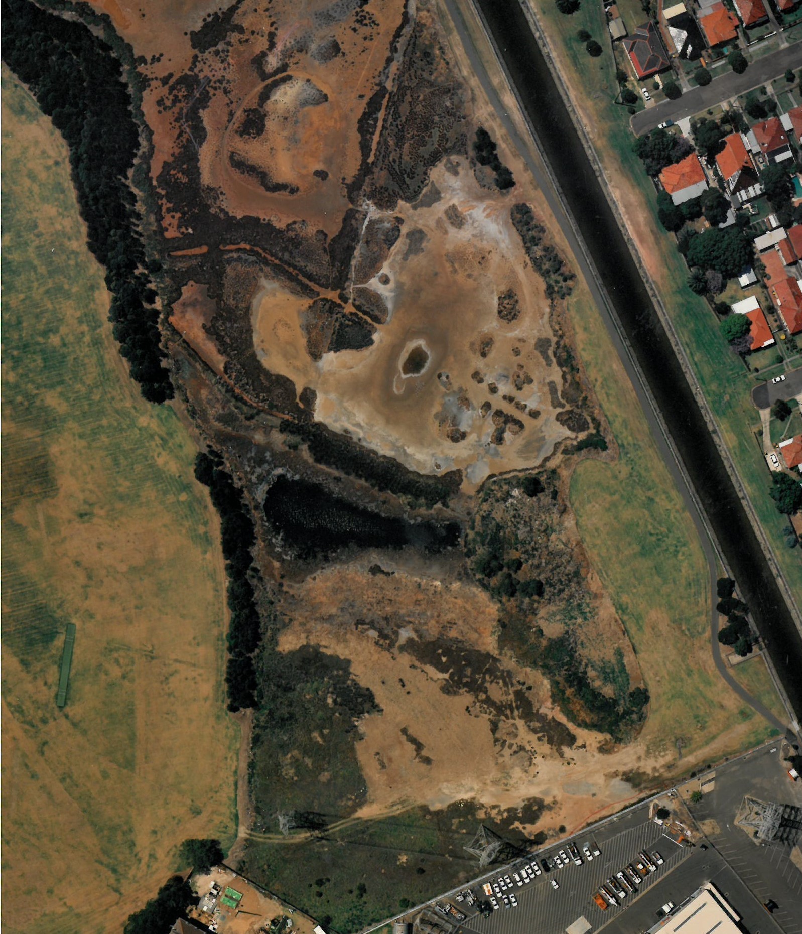
Mason Park has undergone numerous changes during its lengthy history. The area around Powells Creek Homebush, which is now occupied by Mason Park, was fringed by mangroves, mudflats and large areas of saltmarsh. Originally the waterways were natural, and Powells Creek followed a meandering course to Homebush Bay. The area was low lying and subject to tidal inundation as waters were discharged into the area by Powells Creek. Tidal fluctuations provided a challenge for the ongoing development of the area. This area was locally known as ‘The Mangroves’ and ‘The Swamp’.


The boundaries of Powells Creek continually changed depending on the level of rainfall. Councils of the day and the community called for the NSW Government to canal the river system to deal with flooding and support reclamation of the ‘Swamp’, through landfill and waste tipping, into usable land, usually for park purposes. Both the former Homebush Council and later Strathfield Council supported reclamation of the places they referred to as ‘swamp’ land. In 1963, Mason Park was described by the former Strathfield Council Town Clerk James Mathews as ‘approximately half of this Park has been filled with garbage and the level raised to that as we now know it. The remainder is the original mud flat covered with swamp grass’.
As parts of the ‘Swamp’ were filled, a park was created which was then named Mason Park, after Albert Mason, a former Mayor of Homebush. The landfill process continued for many decades. Therefore, therefore the land which we today recognise as Mason Park continually expanded due to landfill activities.
By 1929, sufficient land had been claimed to create a park at this site and from the early 1930s, the land was primarily used as the home ground of the Homebush Rugby League Football Club. However, while part of the land which had completed reclamation was being used for recreation, the Council continued to fill the ‘swamp’ with more fill. Mangroves were removed under Depression employment schemes during the 1930s. Homebush Council also accepted waste fill from local employer Arnotts Biscuits and the Department of Main Roads. The Council also operated waste tips in the park as another method of landfill. The location of the tip would change once sites were filled. The last garbage tip closed in 1977 in Bressington Park (which was originally part of Mason Park), when the site was capped and levelled off.
The Park as a venue for sport and recreation became more popular over time and provided facilities for football and cricket as well as picnics and a children’s playground. Homebush Council supported the increased use of the park by installing amenities including toilets and showers in the 1930s. Mason Park’s facilities have continued to be upgraded and now include large multi-use sportsgrounds, a children’s playground, amenities and carparking.
In 1934, a drainage channel was constructed from around Parramatta Road to Powells Creek. It was called Saleyards Creek as it flowed from the Homebush Cattle Saleyards then located near Parramatta Road. Powells Creek also was straightened, realigned and developed into a concrete channel in 1934. Powells Creek was the boundary between Concord and Strathfield Councils (now City of Canada Bay and Strathfield Councils). In 1934, a footbridge was installed at the end of Mena Street to facilitate pedestrian access from Homebush to Concord West across Powells Creek.
In 1956 the decision was made to divide Mason Park into two portions bounded by Saleyards Creek. The northern portion was renamed Bressington Park. A portion of Bressington Park was further divided with the construction of Homebush Bay Drive and land to the north became part of the new Bicentennial Park (Sydney Olympic Park and City of Parramatta Council). Therefore, over its history, the boundaries of Mason Park changed considerably.
The Mason Park Wetlands are effectively what remained following decades of landfill which changed the landform and concreting of waterways which completely changed the hydrology of the area. Interest in protecting and preserving the Wetlands became a political issue in the 1970s, especially as the Wetlands were a key location for migratory birds, and actions to continue to fill the remaining Wetland ceased. This part of Mason Park was retained as an estuarine wetland, providing habitat resources for several key protected natural assets, including migratory shorebirds (Australia has three bilateral migratory bird agreements with Japan (JAMBA), China (CAMBA) and the Republic of Korea (ROKAMBA), estuarine saltmarsh (a threatened ecological community protected under the NSW Biodiversity Conservation Act 2016) and Wilsonia backhousei (a threatened flora species protected under the NSW BC Act 2016). Areas of regenerating bushland around the wetlands include patches of Estuarine Swamp Oak Forest, another threatened ecological community (protected under the NSW BC Act 2016).
Over recent decades, a shared pathway was installed alongside Powells Creek, connecting to the Bay to Bay pathway which runs from Botany Bay to Homebush Bay, attracting large amounts of pedestrian and cycle movement. In 2018, Sydney Water transformed a section of Powells Creek into a natural waterway, through removal of the old concrete banks and replacement with sloping banks made from sandstone and native plants. A pedestrian bridge across Powells Creek was installed near Lorraine Street in 2022 to enable pedestrian and cycle access to and from Mason Park.
Mason Park was gazetted as a reserve in accordance with the Geographical Names Act 1966 on 19 November 1976.

Thanks so much Cathy. What a good capture….such a history of wetland habitat loss and gradual return to what Mason Park (or perhaps its Indigenous name) is today – a legacy for locals and others to truly enjoy and respect. I feel I have been a small part of that amazing urban wetland!
cheers
Andrew
LikeLike
Hi Andrew, thanks for the comments, hope you are keeping well. I am always rewriting these histories, there is always more to find out. Cathy
LikeLike
hi Cathy, am going ok thanks. Yes, definitely more to uncover at MPW. Have just been reading Louisa Meredith’s 1844 “Notes and Sketches of NSW” (now available in pdf, Ch 14 on Homebush is very interesting….days of quolls, dingoes, scarlet robin, whipbird & so many waterbirds!). In prep for an art & wildlife event this Sat 8th onsite, my first collab with architects & artists!
LikeLike
Andrew, Yes I have read it (well parts relevant to the local area). She has provided amazingly detailed descriptions, life back then was not easy. It is a genuine treasure to find such excellent first hand observations documented, it is truly rare. Cathy
LikeLike
A genuine treasure indeed, Cathy (her time in Tasmania was fascinating too, kind of ahead of her time was the feeling I had). I wonder what other treasures on MPW’s natural and human history might exist out there….although I’m sure you have found them too!
LikeLike
I find it hard to fully understand the histories around the wetlands and powells creek. Trying to follow the land use, ownership, filling activities etc is not straightforward. I am continually compiling information snd maps but lots of pieces are still missing. At least I can finally confirm both Mason Park and Bressington were part of the Wentworth Estate. Cathy
LikeLike
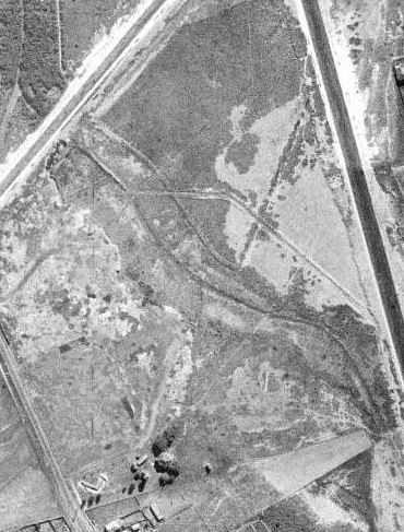
yes, I saw those gaps/missing pieces too. Perhaps it’s a reflection of poor or incomplete documentation of key events at MP such as the infilling episodes (ie. where actually and when) and changes in industrial land use types (brickworks, nightsoil disposal, rubbish tipping etc)? Of-course, GIS-aided mapping was unavailable back then but aerial photos may be helpful ( and very few ‘old-timers’ would be still around?). Sounding like a State Library challenge for someone?
Andrew
LikeLike
Andrew. I have some aerial maps and have been documenting history of land use but records aren’t great, most incomplete and are longer in existence. I don’t think much consideration was taken as the most wanted the sites filled and mosquitos gone. Cathy
LikeLike