By Cathy Jones (updated 2023)
The Cooks River is 23 km in length and runs from Botany Bay in Sydney’s Eastern Suburbs to Graf Park, Yagoona in Sydney’s West. The Cooks River Catchment is about 100 square kilometres with a population of over 520,000 (2022). It is one of the most densely urbanised regions of Sydney. The River’s major tributaries are Wolli Creek, Alexandra Canal (formerly Sheas Creek), Cup and Saucer Creek and Coxs Creek. 53% of the Strathfield LGA is located in the Cooks River catchment. This local waterway provided camping, fishing and hunting grounds for the Aboriginal Wangal clan of the Darug Tribe for thousands of years, prior to European settlement.
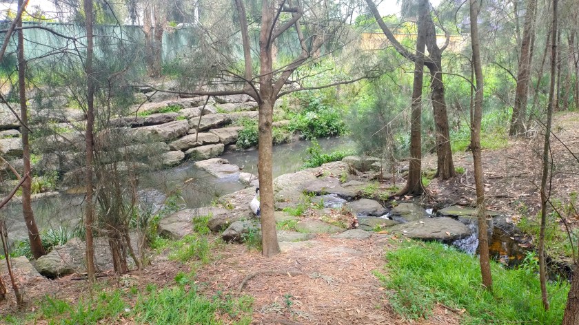
The portion of the Cooks River, located in the Strathfield district, is in the upper reaches of the catchment. The River enters through the southern area of the Strathfield Council area from the junction of Coronation Parade and Punchbowl Road to Water Street Strathfield South. The River connects with the Coxs Creek tributary at Water Street with the River continuing through Strathfield South and then through to Freshwater Park, Strathfield With the exception of a small naturalised section in Freshwater Park, the Cooks River and Coxs Creek are channelised in the Strathfield area.
The Cooks River and its foreshore in the Strathfield Council area has been severely modified, straightened and is unrecognisable when compared to its original form.
While the Cooks River in the lower reaches features open river, the River in the Strathfield area was originally a series of waterholes and ponds rather than a continuously flowing body of water. The path of the river and its banks were difficult to define and the water flow was variable (Tyrell 2018). In the Strathfield area, the river system presented as a riparian landscape or ‘riverscape’, where water travelled unevenly and was absorbed across the floodplain and associated wetlands (Tyrell 2018).
The river in the Strathfield area was described by C A Henderson in his 1923 recollections of early Strathfield and Homebush as a ‘chain of ponds’ (Henderson, 1923) because the river was located on low lying land and appears as a series of small ponds and land depressions, rather than as an open river. When it rained, the ponds would rapidly fill and with evaporation, the ponds would empty. The result of these events is that low lying land would fill very quickly from water events which resulted in many drownings of people, especially children, and animals in the River. The remaining stagnant water left in the ponds would slowly evaporate after the water event finished and attract mosquitos.
In Strathfield the modifications to the river changed the river ‘from a meandering creek with a series of pools with plentiful bird and aquatic life to a concrete channel with straight sections up to 300 metres long’ (Howard 1978). During the process of channelisation the river, the natural paths of the River and its foreshores were significantly altered.
Works commenced in the 1930s on the section of the River from Coronation Parade/Punchbowl Road to Water Street and Coxs Creek tributary. During this process, the natural alignment of the River was substantially altered and straightened in the process. The channelisation of the river flowing west of Water Street did not commence again until the mid-late 1960s, after significant lobbying by Strathfield Council and the Cooks River Valley Association to the former Metropolitan Water & Sewerage Board (now Sydney Water). In the early 2000s, a small part of the Cooks River at Freshwater Park was naturalised.
Over time, the River system became severely compromised, with its many ecosystems damaged or destroyed. Virtually all of its original vegetation, including the Cooks River/Castlereagh Turpentine-Ironbark Forest, has been cleared with only fragmented remnants surviving. By the early to mid 20th century, urbanisation, industrialisation and channelisation erased the original landform, path and character of the River system including its foreshores.
The Bay to Bay is a regional pathway network that runs from Botany Bay to Homebush Bay. The Bay to Bay shared pathway is built on the northern bank of the River and passes through thirteen foreshore parks and reserves. In the Strathfield area, the network connects Cooks River to Powells Creek Homebush (which runs to Parramatta River) by pedestrian and cycle pathways.
References
Henderson, C (1923), ‘Sydney to Homebush 1855’, Royal Australian Historical Society Journal and proceedings Vol. VIII, Supplement 1923.
Howard, Harry & Associates (1978), Cooks River Open Space Municipality of Strathfield
Tyrell, Ian (2018), River Dreams, UNSW Press.


Excellent coverage of the history of the area, It filled in the missing gaps that I didn’t know.
LikeLike
Just wondering, where did you take the first and fourth picture at the bottom of the page? Currently doing a uni project on this but don’t know where to find those locations to take a photo of my own. Thank you.
LikeLike
Gerard, the photos were taken in the section of the Cooks River that has been naturalised near Freshwater Park. If you go to Augusta Street, near the bridge crossing to Cave Road shops, you should have no problem finding this area. Regards, Cathy
LikeLike
Thanks Cathy! Been going around the entire Strathfield stretch of the river today and this was the only accessible naturalised section I could find. Unfortunately, a good section of the river is surrounded by Strathfield Golf Club so I’m not too sure if there is anything worth noting there in regards to riverbank restoration.
LikeLike
Has there been any sort of naturalisation work at the part of the Cooks River that flows through Strathfield Golf Course?
LikeLike
Gerard, I have added some information on this project https://strathfieldheritage.com/parks-and-reserves/cooks-river-strathfield-timeline/cooks-river-freshwater-park-rehabilitation/. Regards Cathy
LikeLike