
By Cathy Jones
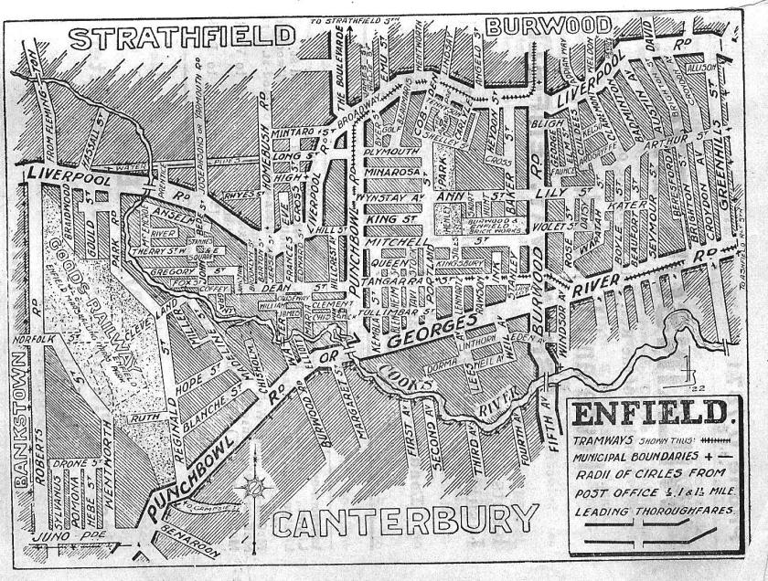
The suburb of Belfield is located partly in Strathfield Council and Canterbury-Bankstown Councils.
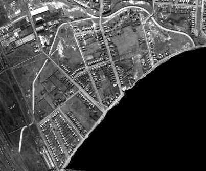
The section of the suburb of Belfield located in the Strathfield Council area measures 52ha (about 1km2) and is bounded by the Cooks River and Coxs Creek Stormwater Channel at the north and Punchbowl Road at the south, Cosgrove Road (at west) and Coronation Parade (at east).
Belfield is located in the southern area of Strathfield Council. The suburb has an estimated resident population in 2020 (ABS) of 1,502, with a population density of 28.71 persons per hectare. This area is primarily residential with large amounts of parks, sports grounds and open space.
Origin of the name
The name ‘Belfield’ appears to be a construction of the names of adjoining suburbs Belmore and Enfield, however its’ origin is subject to some debate. Some believe that it came into usage after the opening of the Enfield Marshalling Yards in 1916, others state that the name Belfield originated with actions of local residents to establish a local post office in 1936. The postal inspector reported in favour of a non-official post office in his report (quoted in Madden 2002):
‘…There is a business centre here consisting of sixteen shops, one garage and one Hotel. It is a prosperous business section. This part of the locality is approximately mid-way between Belmore and Enfield. It is known as Belfield”.
The business centre was and is located in the Canterbury-Bankstown area.
Most historic references to this area such as Electoral Rolls, Valuation Lists etc, until at least the 1960s refer to streets in this area as Enfield. It is uncertain when this area located in the Strathfield Council area became commonly known as Belfield. The first references to Belfield relating to areas covered by Enfield Council (later part of Strathfield Council) appear in representations made to Enfield Council by the ‘New Belfield Progress Association’ in September 1940 and again in January 1942 for actions on condition of Reginald Street (now Cosgrove Road) by the Belfield Branch of the Australian Labor Party (Enfield Council minutes 3 September 1940 and 27 January 1942).
The suburb name was first gazetted in 1977. More research would be needed to ascertain how and when the suburb name was changed, however it appears that it was a gradual process where the name of Belfield became increasingly used to describe this area.
The area of Belfield, bounded by Punchbowl Rd, was originally part of the west ward of Enfield Council but was absorbed into Strathfield Council in 1949, along with the suburbs of Strathfield South and part of Greenacre.
Early European settlement
One of the oldest European settlements in the Strathfield Municipality was located in present day Belfield. Land grants commenced in 1809 with a grant of 60 acres to John Alford. In time, Alford and other small grants were sold and consolidated into larger estates. One of these was the 250 acre ‘Clareville’ Estate, the home Judge John Stephens [1771-1833], the first Supreme Court Judge of NSW. Stephens was also the cousin of writers Virginia Woolf and Vanessa Bell.
‘Clareville’ was located on the banks of the Cooks River. Stephens died at ‘Clareville’ in 1833 and this estate was acquired by Charles Elliott in 1849 and subdivided into smaller residential allotments in 1903 establishing streets and residential land lots on street such as Water Street, Elliott St and Punchbowl Road. The street name Clareville Close, which intersects with Elliott Street was derived from the estate ‘Clareville’.


Until the start of World War 1 in 1914, Belfield was sparsely population and most of the area being used for farms, dairies, piggeries, poultry farms, potteries and market gardens. Some homes dating from the late 19th century, reflecting this history, are still in existence in Madeline Street.
Homes developed as employment opportunities increased with the establishment of the Metropolitan Goods Line from Flemington to Glebe Island and Darling Harbour via Campsie and Dulwich Hills in 1910. The first section from Flemington to Campsie was opened in 1916 and the line opened to Glebe Island a few months later (Muir & et al; 2002: 4). The large Enfield Marshalling Yards opened in 1916 and attracted railway employees to Enfield and surrounding suburbs. It became a large local employer. Streets such as Birriwa Avenue and Cutbush Avenue were developed around this time and were mainly built by local builder, William Francis Bush.
Another wave of residential development in Belfield occurred after World War II with the building of War Service and Housing Commission homes in streets such as Patricia Street, Robinson Street and Victory Avenue. A plaque can be found on the corner of Punchbowl Road and Cecily Street commemorating the opening of the housing project in 1948. The plaque states:
Belfield Housing Project
Dedicated and Unveiled by
the Hon. Clive Evatt
Minister for Housing
19 June 1948
Parks
Belfield contains significant parks and open space. Large parks include Cooke Park, named for Thomas Cooke, the final Mayor of Enfield Council in 1948 and Begnell Field, named after Jim Begnell.
Parks located on or near the Cooks River and Coxs Creek such as Elliott Reserve, Maria Reserve and Bark Huts were developed on land reserved in 1951 by NSW Government for a proposed roadway along the Cooks River travelling from Botany Bay to Chullora. The plan for the ‘Cooks River Country Road’ was eventually discontinued in 1997 and the M5 motorway was built instead, some distance from the former proposed roadway. Elliot Reserve was named for the Elliott family, early landowners in Belfield and Maria Reserve, was derived from Maria Street, in turn named for the wife of early landholder Edward Saunders.
Acknowledgement is given to the Canterbury & District Historical Society and Canterbury Council Library for their assistance in the research of this article.
References
Currey, C. H., 1967, ‘Stephen, John (1771–1833)’, Australian Dictionary of Biography Vol.2, National Centre of Biography, Australian National University
Enfield Council, 1940, Council minutes 3 September
Enfield Council, 1942, Council minutes, 27 January
Jones, C., Parks in Belfield (refer links)
Madden, B., 2002, History of Belfield, viewed at http://www.canterbury.nsw.gov.au/history/hisbelf.htm on 12 June 2002
Muir., L & Fortier, R., 2002, Belfield History and Memories, Canterbury & District Historical Society
Mowle, L, Pioneer Families of Australia, pps327-342
Thomas, Bryan, 1982, The Original Colonial Landowners of Sydney
Wilson’s Street Directory 1926
© Cathy Jones 2004, updated 2018, 2021.

Lovely saburb been living 20 years now. Soo happy to live in here.
LikeLike
Dear Cathy,
I don’t want to see another change of the history to the name Belfield. I have lived on the Strathfield Council side of Belfield all my life. For no reason, someone councillor or officer in Strathfield Council has proposed to rename the Strathfield side of Belfield as Strathfield South. As far as I can recall, many Gregory’s-branded street directories printed in the 1970s referred to streets such as Robinson St as being in Enfield, not Belfield. I have always known living on the Strathfield-side of Belfield as Belfield even though it was officially gazetted in 1991 (source article: History of Belfield And Memories – please correct me on this).
To change the Strathfield side of Belfield to Strathfield South may well be a source of confusion for motorists. To illustrate, when you enter Belfield from Georges River Rd, you will see a sign provided by Canterbury Bankstown Council indicating “Belfield”. People continuing to drive all along Punchbowl Rd (continued from Georges River Rd and Coronation Pde (originally known as Punchbowl Rd), will believe they are driving through Belfield and not Belfield (on the left) and Strathfield South (on the right).
Conversely, for motorists driving along Punchbowl Rd from Wiley Park will be seeing a sign provided by Strathfield Council labelled “Strathfield South”. They will think that they are driving through “Strathfield South” and not “Strathfield South” (on the left) and “Belfield” (on the right).
What about those who travel along Water St (on the Strathfield Side), cross Punchbowl Rd into Burwood then enter the Belfield Shopping Centre with its Belfield Post Office. By the way, one of the original reasons for the naming of the suburb of Belfield was the establishment of the Belfield Post Office. Also, the name Belfield may have had its origins from the first house of worship, Belfield Methodist (now Uniting Church) advertising its church services between Belmore and Enfield, source, https://belfield.nswact.uca.org.au/about/
Then there is the issue of correspondence by snail mail and parcel delivery. I should not have to change my postcode from 2191 to 2136. Despite the option of bills being delivered by email, snail mail is important for documents from government departments and utilities. It would be a burden to remember to contact government departments, utilities, other services and friends to update their records.
In sum, I am extremely reluctant to change the Strathfield side of Belfield to Strathfield South for historical, administrative and navigational reasons.
Thank you,
Anthony of exciting Belfield
LikeLike
Anthony
You probably need to contact Council with your concerns. Change of name would require agreement of the NSW Geographical Names Board. Names of suburbs in this area have changed many times. People tend to be passionate about names of suburbs, particularly if they are life time residents. Most old records refer to streets in the Strathfield Council portion of Belfield as Enfield. Enfield now has shrunk to only a few streets.
Cathy
LikeLike
Dear Cathy,
Thank you for the response. I have submitted my concerns to the council via the council’s webpage a few months ago as soon as the issue raised by council was ‘snail’ mailed to residents. So I await a response.
In my anecdotal and extremely small sample survey, I asked a few residents what they thought on the proposed name change of Belfield, a typical response was that they were not happy and “…there was nothing we can do…” .
In the same way, I would be extremely reluctant to even have the name Belfield changed to Belfield Gardens, Belfield Heights, Belfield Grove, Belfield Hill, Mount Belfield, Belfield upon Cooks, Belfield upon Cox
Thanks,
Anthony of exciting Belfield
LikeLike
Personally I think it’s a great idea. I have lived in Strathfield’s LGA FOR 36 years and want to be Strathfield South as we are a part of this municipality. Our neighbours also asked , felt that the name change would reflect where we live . Robinson st Strathfield south has a lovely ring to it.
LikeLike
Cathy Jones,
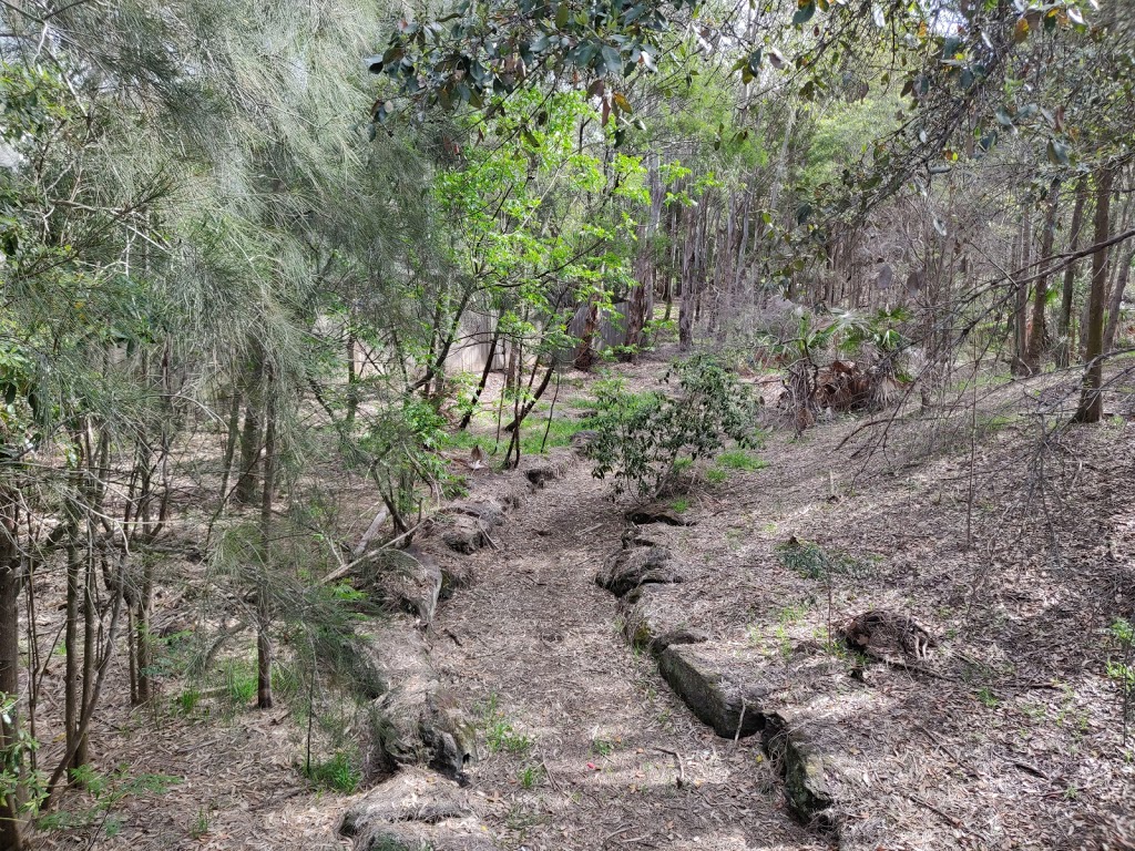
Do you have any idea what the road like (or is it canal like?) structure is at Maria Reserve. It can be seen on 1943 aerial photos. There is a wooden bridge that goes over it.
LikeLike
Deborah, I thought you were referring to the bridge over the river at Maria Reserve, but is this the footbridge in the reserve itself? Cathy
LikeLike
Yes it’s in the reserve. You can see the area I’m talking about in these pictures. The bricked path, stream, road??? interests me. I’d love to know more about the history of this reserve. https://cdn.australia247.info/assets/uploads/77e695fb9988494f29085bba08ad0c84_-new-south-wales-strathfield-municipal-council-belfield-maria-reservehtml.jpg
LikeLike
See article on Maria Reserve https://strathfieldheritage.com/parks-and-reserves/maria-reserve-belfield/
LikeLike