By Cathy Jones (2019)
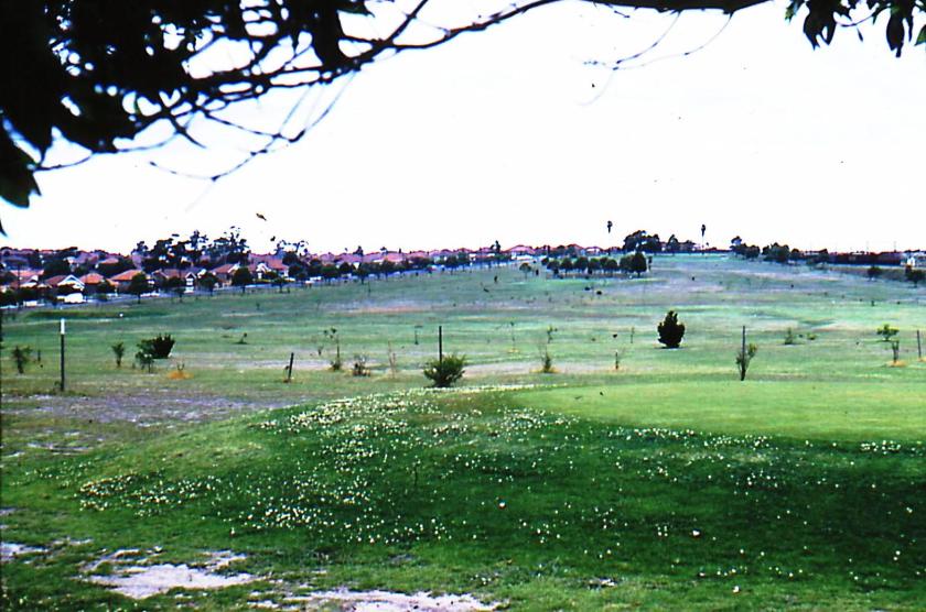
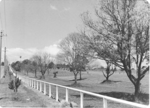
Hudson Park, Strathfield is bounded by Centenary Drive (west), Arthur Street (north) and Mitchell Road (east) and at its southern border it joins Frank Zions Reserve. It is the largest park in the Strathfield district and is about 16.9 hectares in size. The park is bisected into two sections by Centenary Drive.
Hudson Park is located on land once controlled by the Church of England Cemetery Trust as reserve land for Rookwood Cemetery. The building of the freight railway line to the Enfield Marshalling Yards separated this land from Rookwood Cemetery in 1914.
Hudson Park is located on Crown Land. There is a small lot of land which appears to be an disused extension of Richmond Road from Arthur Street to the freight train line. This land was intended to be a road to connect Arthur Street to Rookwood Cemetery by a bridge across the railway, but it was never built. The description of this land is described as being “vested in fee-simple in the Railway Commissioners for New South Wales of strips 20 feet wide along each side of each roadway”[1].
Other than these exceptions, the land was resumed by the NSW Government as Crown Land. Strathfield Council sought for many years to acquire the land for public recreation as the land was located in the Strathfield Local Government Area and except for grazing, remained unused. Though it was intended to be part of Rookwood Cemetery, it was never used as cemetery land. On 3 October 1930, the NSW Government gazetted the land for public recreation and transferred control and management to Strathfield Council.
Early uses – cricket and grazing
In 1932, Council undertook improvement works to the park and tree planting around the ornamental pond using loans from the Unemployment Relief Works Act 1932[2]. A cricket pitch was laid in 1933 by the Returned Sailors and Soldiers League – Sports Branch[3] In 1933, long serving Alderman and former Mayor John Robert Firth and his wife donated a clump of trees as a memorial to their late son Bernard in the park[4]. The Firth memorial was later vandalised and in 1954 was replaced with a memorial tablet[5]. In 1935, water and sewerage pipes were connected to the park. In 1936, two additional cricket pitches were added to the park. In 1946, a further 4 cricket wickets were added to the park[6]. In 1948, an additional 3 cricket wickets were added[7]. In addition to these uses, part of the park was leased on occasion for grazing purposes. These uses ceased however with Council’s decision and via agreement of the Minister in 1955 to develop a public golf course on the site[8].


Hudson Park Public Golf Course
The nine hole Strathfield Municipal Council Hudson Park Golf Links, as it was originally called, was officially opened on 15 September 1956 by the Minister for Local Government, Mr J B Renshaw[9]. Eddie Anderson, five times Open Champion of Queensland was appointed as the Golf Professional of the new public course. Anderson was followed by Terry Bolger from 1958-1974. Plans were approved for construction of a brick structure with toilets, storage, work and plant room[10].
To support the new course, the Metropolitan Water, Sewerage and Drainage Board increased its supply of water to the park from 4000 gallons to 23,000 gallons[11]. In 1976, surveys for the construction of the County Road (which became Centenary Drive) commenced. This road ran through the golf course which required a redesign of the course and the building of an underpass under Centenary Drive to allow accessibility to both sides of the course. In August 1985 work commenced on Homebush Bay Drive, which joins Centenary Drive and links Parramatta Road at Homebush West to Concord Road at Rhodes. In December 1990 Homebush Bay Drive was opened to traffic between Rhodes and the M4 Motorway, with its southern end joining Parramatta Road directly across from Marlborough Road. Centenary Drive was widened to six lanes in December 1996 and the four-lane overpass connecting Centenary Dr and Roberts Road opened in August 1998.
In 1978, Strathfield Council opened a Night Golf Driving range to complement the course. In 2019, Hudson Park Golf Course closed operations due to falling patronage numbers, while the Driving Range was retained.
Redevelopment of Park
Strathfield Council developed plans to transform the site into a park. Stage 1 works included a new lake, multipurpose courts, increased tree canopy and areas for passive recreation. Stage 1 of works was completed in 2022 and stage 2 works were completed in 2023 and included additional shade and seating, off-leash dog park, BBQ and sheltered picnic areas, children’s playground, outdoor fitness equipment, sports courts for basketball and volleyball, outdoor table tennis tables and toilet amenities.
Naming of Hudson Park
The park was originally known as ‘Hampstead Downs’. In 1935, the Council renamed the park ‘Hampstead Park’[12]. In 1953, Council requested permission from the Department of Lands to change the name of the park to Hudson Park. The Department eventually agreed though they preferred the name of ‘Flemington Park’[13], a name that occasionally appears on old maps. The park was renamed in 1953 after Colin Hudson (1894-1975), a former Mayor of Strathfield [1944-1949]. Hudson served as an Alderman on Strathfield Council from 1941 to 1952 and once held the record as longest serving Mayor.
Hudson Oval
In 1958, St Patrick’s College requested Council build a sports oval at Hudson Park. In late 1958, Council made application to the Minister for Lands for consent as Hudson Park is Crown Land and required State Government approval for major changes[14]. In late 1959, the Minister for Lands consented to the building of an oval in Hudson Park[15]. Council resolved in principle to enter into a 20-year lease agreement with St Patricks College for use of the Oval which involved financial contribution of £2000 from St Patricks’ College as partial contribution for the oval construction[16]. The remainder of the cost was funded by Council through a loan program.
At a special meeting on 12 January 1960, Council varied its estimates for the 1960 year with the inclusion of £8000 estimated expenditure for Hudson Park Oval. In September 1960, Council called for a tender to construct the Arthur G. Lowndes’ Oval at Hudson Park at an estimated cost of £7,955[17]. The tender was awarded to Nicholas Panos Pty Ltd in November 1960 for £8,720, being the lowest tender[18]. St Patrick’s College agreed to contribute to the shortfall of £720 between the estimate and tender. In acknowledgement of the financial contribution from the school, the rental of the oval was set at £10 per annum, a ‘peppercorn’ rent[19]. Construction of the oval was completed in early 1961.
The building of the oval involved increases of expenditure to Council beyond the loan program commitments. As an example, in 1965, Council estimated its expenditures on Hudson Park Oval at £700 annually against a total of £35 income.
While the oval was named after Arthur G Lowndes, a former Strathfield Council Alderman, the Oval is more widely known as Hudson Oval.
Hudson Park was gazetted as a reserve in accordance with the Geographical Names Act 1966 on 19 November 1976.


References
[1] For Public Recreation (1930, October), NSW Government Gazette, page 3944
[2] Council minutes, 28 June 1932 & 6 September 1932
[3] Council minutes 31 October 1932
[4] Council minutes 14 November 1933
[5] Council minutes 23 November 1954
[6] Council minutes 27 August 1946
[7] Council minutes 7 September 1948
[8] Council minutes 10 October 1955
[9] Council minutes 15 August 1956
[10] Council Health & Building Committee 17 April 1956
[11] Council minutes 4 August 1957
[12] Council minutes 23 July 1935
[13] Council minutes 6 January 1953
[14] Council minutes 28 October 1958
[15] Deputy Mayor’s Report to Council, 19 November 1959
[16] Deputy Mayor’s Report to Council, 19 November 1959
[17] Council minutes 27 September 1960
[18] Council minutes 22 November 1960
[19] Town Clerk’s Report to Council, 21 June 1960

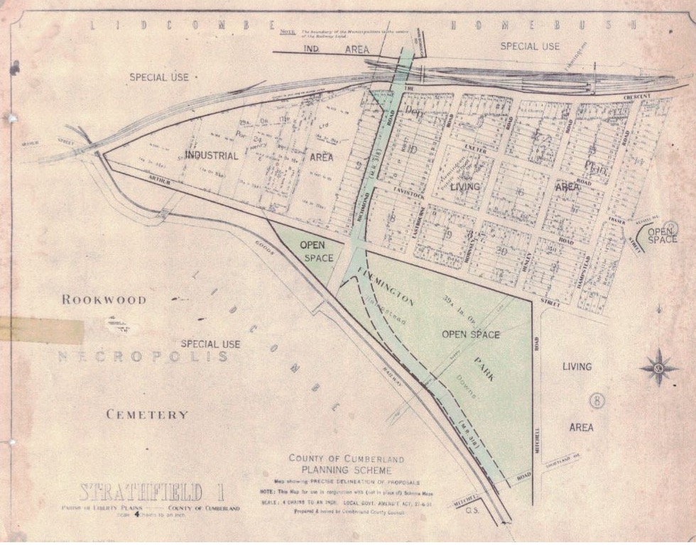
i believe Centenary Drive was completed close to 1985 close to the Centenary of Strathfield Council rather than the 70’s as suggested
LikeLike
Bill, I meant that provision for the road was made in the design of the park and the then golf course in the 1970s. The map is undated but drafted many years before work actually commenced. The first stage of Centenary Drive was first opened in December 1984. Centenary Drive replaced Mitchell Road and Pemberton Street as the main access road linking Strathfield from the north (Arthur St) to south (Liverpool Road), running adjacent to the freight railway which had opened in 1916. The need for a new road bypass was set out the in 1951 County of Cumberland Planning Scheme and county land reserved for this purpose.
In August 1985 work commenced on Homebush Bay Drive, which joins Centenary Drive and links Parramatta Road at Homebush West to Concord Road at Rhodes. In December 1990 Homebush Bay Drive was opened to traffic between Rhodes and the M4 Motorway, with its southern end joining Parramatta Road directly across from Marlborough Road. Centenary Drive was widened to six lanes in December 1996 and the four-lane overpass connecting Centenary Dr and Roberts Road opened in August 1998.
Regards
Cathy
LikeLike