
On June 2 2018, Strathfield Council celebrated its 133th anniversary of its incorporation in 1885.
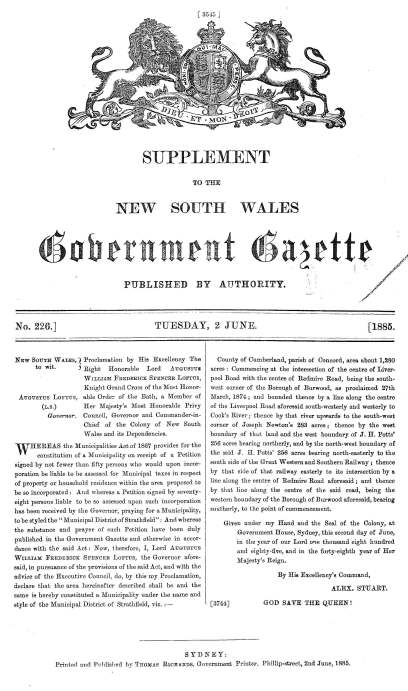
In 1884, residents of the Strathfield, Strathfield South and Homebush areas petitioned the State Government demanding the right to manage and control their own local area. After considering petitions (and counter-petitions) from residents, approval was granted to establish local government by the NSW Governor, Lord Loftus, in 1885.
The new Council of the Municipality of Strathfield included the areas of Redmyre (now Strathfield), Homebush and Druitt Town (parts of Strathfield and Strathfield South). The new Council was named Strathfield to avoid disputes between the three suburbs.
The name ‘Strathfield’ was derived from a local home ‘Strathfield’, which was built for the former Lord Mayor of Sydney, Walter Renny c.1868.
By 1886, the Redmyre Rail Station altered its name to Strathfield Station. The suburb of Redmyre was also renamed Strathfield.
The original municipal area was bounded by Liverpool Road and Cooks River to the south, Pemberton Street to the west, the Sydney-Parramatta railway line to the north and The Boulevarde to the east. The boundaries of the Council area have expanded considerably since this time.
The Echo (1890) reported that the:
“area of the municipality is estimated at 1280 acres, with 19 miles of streets. The population, at the date of the incorporation, was estimated at 550, living in 130 houses, and the net revenue was £1210 7s 10d from the general rate, The capital value of rateable property was about £222,600, while for the current year it is £303,000, the increase representing new buildings and improvements, as the value of land has not increased during the past five years.”
In 1892, the area of Flemington (now Homebush West) was added to Strathfield Council. In the 1940s the west ward of the former Enfield Council (1 January 1949) and former Homebush Council (24 May 1947) was added. Strathfield Council currently is 14.1km² in size and includes the suburbs of Strathfield, Strathfield South, Homebush, Homebush West, parts of Belfield and Greenacre.

The first meeting of Strathfield Council was held on 19th August 1885 at ‘Llanelly’ [now ‘Steephurst’] 22-24 Albyn Rd, to elect the first Aldermen. The first Aldermen elected were Albert Allen, George Hardie, Wilheim von der Heyde, Henry Australia Perkins, George Arthur Thompson and James Thompson.
Alderman George Hardie was elected the first Mayor of Strathfield on 31st August 1885. Early meetings of Council were held in private homes, but since 1887, Council meetings have been held in the Strathfield Council Chambers at Homebush Road Strathfield.
Since 1885, a total of 157 persons have been elected as a Councillor (or Alderman prior to 1993), including 18 women. 54 Councillors have been elected Mayor. The longest serving Mayor was Clarrie Edwards from 1976-1984. The longest serving Alderman was John Robert Firth, who served for 39 years from 1908-1947 and as Mayor on several occasions. Eileen Stirk was the first woman elected to Council in 1967. In only two Council terms, those in 2000-2004 and the current term, which commenced in 2017, have the majority of councillors have been women. The next Council election is scheduled for September 2020.


Strathfield is known for its parks, education, transport, heritage and homes on tree lined streets. Over 133 years, some of the developments which have shaped the Strathfield area include:
Boulevarding programs
In the 1880s, Council adopted the ‘Boulevarding’ program which established the design and unique ‘look’ of Strathfield. The design was based on a miniature version of 19th Century French influence by George Haussman involving wide, straight, tree lined streets, with wide footpaths for afternoon strolls.
As reported in The Echo (1890) “the old road which divides the municipality from Burwood has been named the Boulevarde, and it was on this road that tree planting was begun. On this account the word “boulevardeing” came into use, and the ratepayers have since been notified that any person wishing the road in front of his residence “boulevarded” can attain his desire by agreeing to pay one-third of the cost, the council undertaking to defray the balance of the expenses’.
The Boulevarding program aimed at creating a pedestrian suburb with wide and safe footpaths connected to civic buildings, monuments or focal points such as parks. The ‘Boulevarding’ program featured wide streets (minimum 66 feet which was significantly wider than the inner city standards of day), footpaths on both sides of the road (to encourage pedestrian access), planting of street trees and kerbs and guttering.
In the late 1880s and early 1890s Strathfield Council took advantage of a state government subsidy towards street planting, and when this was discontinued in 1893, the council decided to continue its street planting policy.

As commented in The Echo (1890) the nature strip on each side of the street
“are fenced in with sawn poets, atop. rail, and three or four wires, In these enclosures pines, various kinds of eucalypts, Moreton Bay figs, oaks, and other trees have been planted at proper intervals, and between these flowering and ornamental shrubs have been placed. In the wider streets, more space can, of course, be given to the road-way, the footpaths, and the “boulevarding.” In some of the streets there are trees 30ft high, which afford a welcome shade in the hot weather, while the smaller plants make the make the streets look like a veritable garden. The visitor can scarcely avoid contrasting these streets with the narrow lane, of some parts of Sydney, Macdonaldtown, Balmain, and other suburbs, and thinking how much more pleasant and healthy these places would be if they could be treated as the Strathfield streets have been. It is little wonder that the people of Strathfield should feel a pride in their municipality.”
As at 2018, there are an estimated 12,500 street trees in Strathfield.
Parks and open space
Strathfield Park was the first park in Strathfield and was dedicated in 1914 after a poll of residents was held to select the site on Homebush Road. From this early acquisition, Council has subsequently acquired about 123 hectares of parks and open space, which is about 9% of the total land area of Strathfield. Large amounts of open space are located near Powells Creek at the north and along Cooks River in the south.
Services
Strathfield’s streets were initially lit by gas lighting, which was later replaced by electricity. Strathfield was one of the first areas of Sydney to establish a water and sewerage system, which was completed in 1912.
The first public library service was established at Parramatta Road Homebush in 1944, which operated until 1976. The High Street Library was first established in 1956 and rebuilt in 2009. The Rochester Street Library was first established in 1976 and rebuilt in 2004. The Library currently services over 250,000 visitors per year.
Transport
The first railway station in the Strathfield area was Homebush in 1855, followed by Strathfield Station in 1877 [then called Redmyre] and then Flemington in 1884. The Strathfield area is also serviced by an extensive road network including the M4 Motorway, Parramatta Road and Liverpool Road (built 1812-1814). The network of local roads, footpaths, kerbs and gutters is built and maintained by Council.
Planning
Strathfield Council was the first Council in NSW to utilise the new planning powers by declaring most of the Strathfield Council area a residential district in April 1920. This proclamation, which continued until 1969, prohibited the building of shops, theatres, industry etc except in restricted areas. The Council also enforced land subdivision standards of generally a minimum 50 feet street frontage on a large land allotment. In comparison at the time, the average Sydney land subdivision was 40 feet frontages or less.
Community concerns regarding potential for house fires and infectious diseases such as tuberculosis, influenza, scarlet fever etc were addressed by Council’s imposition of health and building standards such as prohibition of the building of timber structures from 1920, increased separation between buildings eg buffer space at side and rear to promote healthy living standards and rigorous programs of building and health inspections.
The earliest homes in Strathfield date back to the 1870’s. Strathfield features a wide range of heritage property including Victorian, Federation, Interwar and Post War architecture. Many of Strathfield’s finest homes are listed as heritage items and conservation areas on Council’s Local Environmental Plan. These listings are designed to conserve important heritage items and conservation areas for current and future generations.
Population growth
The Strathfield Local Government Area has experienced rapid growth in population during different periods of its history. From 1911 to 1921, the population of Strathfield rose by 100%, in contrast to the Sydney region increase of 42.8% over the same period (note this figure includes parts of Homebush and Enfield which are now part of Strathfield Local Government Area).
In the 1885, the population of then Strathfield Council area totalled 550 residents. In 2018, the estimated residential population is estimated over 43,585 residents and is projected to increase to over 60,000 by 2036.
From 1921 to 1933, a population increase of 67.8% occurred in Strathfield in contrast to the Sydney region increase of 37.4%, due to significant subdivision in Strathfield. Subdivision involved division of large estates mainly of developed estates in central Strathfield and parts of Homebush north of the railway or vacant land, especially on the southern and western sections of the Strathfield Local Government Area.
The onset of the Great Depression signalled the decline of building approvals of new dwellings in the early 1930s from 106 applications in 1929 valued at £112,358 to 4 applications in 1932 valued at £5525. By 1940 economic conditions had improved with a total of 118 applications for new dwellings totalling £150,955 lodged with Council.
In the Post World War 11 period from 1947 to 1954, population growth slowed to 8.1% against the Sydney region average of 20.9% as land become less available. From 1954 to 1961, growth fell to 0.3% against the Sydney region increase of 17.2%. By the 1950s, most available land was fully developed within the permissible zonings. Zonings were mandated under Council’s Residential District Proclamation, first adopted in 1920, which prohibited building of higher density dwellings such as flats and apartments in most of Strathfield. Similar patterns of development occurred in nearby Council areas of Burwood and Concord which also experienced falls in population during these periods.
Between the 1954 and 1996 Census, the population of Strathfield remained stable measuring around 26,000 to 27,000 people. The stable population was due to the unavailability of vacant land for development and until 1969, the prohibition on building higher density dwellings eg units in most of Strathfield. After the adoption of the Strathfield Planning Scheme Ordinance in 1969, streets close to railway stations were rezoned for units usually ‘walkup’ flats of up to 3 stories in height. Between 1969 and 1971, the number of units in Strathfield LGA increased by 100%, however the overall population did not increase due to declines in household sizes.
Strathfield’s population has increased since 2001, which is attributable to the increase of number of dwellings, primarily medium to high density development. Future estimates based on population projections of NSW Department of Planning.
|
Year |
Population |
|
1861 |
60 |
|
1891 |
1,820 |
|
1911 |
5,652 |
|
1921 |
11,519 |
|
1933 |
19,327 |
|
1954 |
25,829 |
|
2001 |
27,777 |
|
2016 |
42,000 |
| 2021 estimate |
50,400 |
| 2026 estimate |
55,900 |
| 2031 estimate |
60,200 |
| 2036 estimate |
64,900 |
Discover more from Strathfield Heritage
Subscribe to get the latest posts sent to your email.

I am wondering about the date of the photograph of the town hall. Can you advise please?
LikeLike
It is probably late 1920s or early 1930s. This is based on buildings present in the photo. The house was built in 1902, the Town Hall in 1923 and War Memorial opened in 1925. It predates the building of the first floor on the Council Chambers. The first floor was built in 1938 , so it likely the photo is dated from 1925-1938 as the War Memorial was opened in 1925 and there is no first floor featured in this photo.
LikeLike